Abandoned Villages

This area is not exempt from the rural exodus that occurred during the second half of the 20th century. The post-war years brought about a serious crisis in mountain and rural areas, resulting in large-scale migration from these areas to large cities and industries areas.

1960

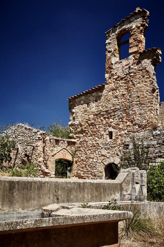
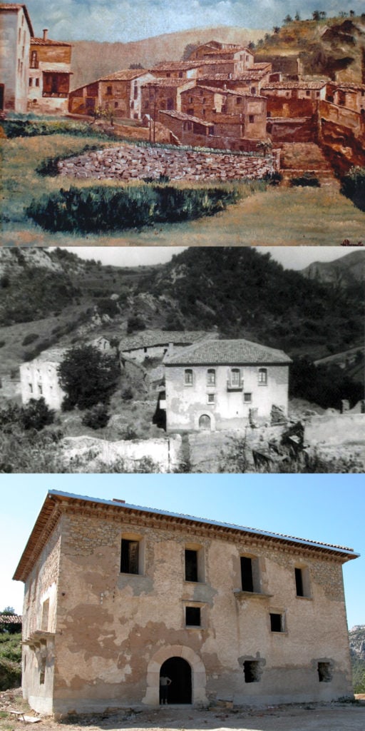
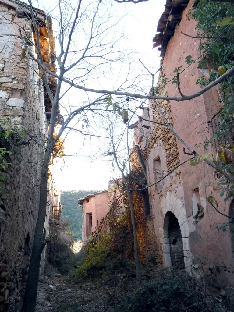
The village of Montfalcó was abandoned in 1960 when the residents sold their buildings and land to the Spanish Forestry Service.
1960

1980

During the 80s, as responsibility for the mountains began being transferred to the Autonomous Communities, Monte 1100, which contains within its borders the village of Montfalcó, started being managed by the Government of Aragón’s Environmental Department.
1980

2004

In 2004, the Ministry of the Environment took charge of compiling an inventory of all the disused properties in the mountains throughout the Autonomous Community of Aragón.
2004

2005

In 2005, the Strategic Plan 2005-2007 was drawn up with the goal of recovering abandoned villages, including eight projects which have since been rolled out and executed:
2005

2009

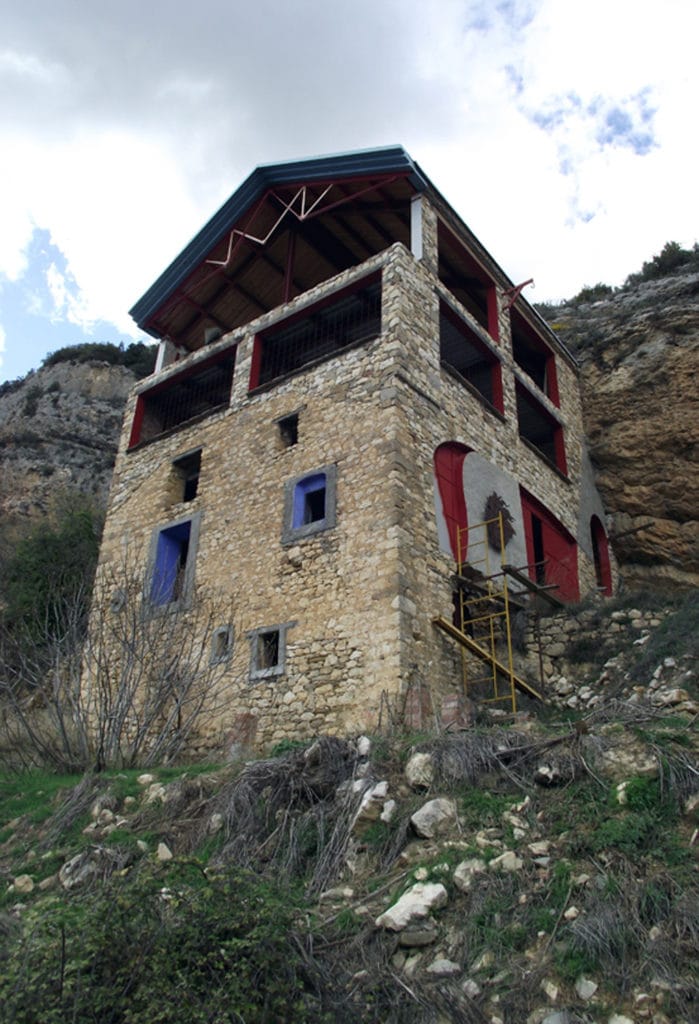
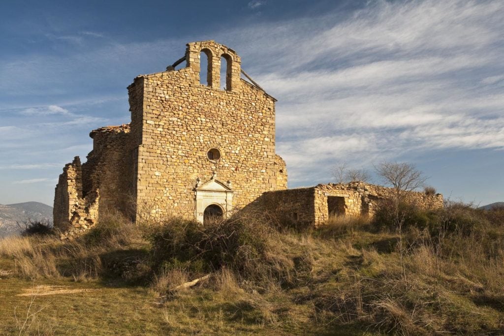
In 2009, Montfalcó Mountain Refuge opened its doors with the goal of exhibiting the area in a respectful manner while doing everything it can to preserve and protect it against the changes occurring in its surroundings.
2009

Montfalcó

Nestled in the heart of the Sierra del Montsec, its ideal location and spectacular views of the Sierra del Montsec, Canelles Reservoir and Mont-Rebei Gorge make it one of the country’s most special destinations. There’s not much left of the abandoned village, just the walls of a few old buildings poking out through the weeds and undergrowth. All that has been spared from ruin and desolation is Casa Valle house, also known as Casa Battle, as well as some of the ravaged remains of the parish church, its cemetery and the wonderful Santa Quiteria and San Bonifacio Hermitage. These are shapes and structures that give us a glimpse into the history of this settlement, which has existed since medieval times, although there aren’t many traces of its roots dating back to this period. It is first mentioned, however, in the 11th century, placing it under the rule of the Counts of Urgell and Barcelona, and again in October 1225 in the Diplomatic Collection of Obarra, which makes reference to a “Bernardus from Mont Falcon”. It is not alluded to again until the middle of the 16th century, while it belonged to the Vereda de Ribagorza in 1646 before it acquired the status of village in 1785. At this point the land was owned by the church, specifically the Diocese of Urgell, and would remain so until the 19th century, then being passed to the Diocese of Lleida. Between 1711 and 1833 it formed part of the township of Benabarre, and it had its own town hall by 1834, even though it continued to belong to its neighbour, eventually joining up with the adjacent town of Fet soon afterwards in 1845. There is plenty of information regarding the population, which varied greatly over the centuries, reaching 56 inhabitants at its peak, a figure it maintained until 1950, when the village was home to nine houses: Valle (Batlle), Mauri, Francisca, Perot, Pañello, Gasparó, Guillén, Maciá and Tomás. Soon after, during the ill-fated 60s, Montfalcó lost all of its residents in one fell swoop as a result of the opening of Canelles Reservoir, as did virtually all of the neighbouring towns and villages, leaving their streets empty and their houses more and more dilapidated, and adding their names to the ever-growing list of abandoned villages in the High Aragón region. Montfalcó’s local festivities were celebrated on 2 September, the date on which the sons and daughters of Montfalcó would, until very recently, join together and come to remember its legacy.

Montgay

The abandoned village of Mongai is located at the foot of the mountain that bears the same name. It is found beneath a large rocky outcrop, completely isolated on the northern slopes of the mountain. The settlement reached its maximum population at the end of the 19th and beginning of the 20th centuries, with six houses built into the rock itself. The village’s isolation was its biggest enemy and the main cause of its abandonment during the 70s. It was an agricultural and farming village, with its crops mostly consisting of wheat and barley, although olives and several vines were also grown there. The town’s church, named in honour of Saint Mary, comprised of a single nave and a straight chevet, covered with a gable roof which supports a small bell tower, and a choir near the entrance. Mongai had the misfortune of being purchased with the intention of building a small luxury residential complex. The project came to a halt and to this day, four half-finished bizarre-looking structures can still be found scattered around, ruining the landscape.

Chiriveta

Chiriveta is the easternmost village in the Aragonese part of Montsec. It belongs to the town of Viacamp i Lliterà and over 90 people called it home in the 1940s. After completion of the Canelles Reservoir, its inhabitants seemingly vanished, and since the 80s, just a single family has remained in Chiriveta. That’s why part of the village is abandoned and in ruins. Despite this, you can still find excellent examples of traditional architecture, homes with their own bread ovens and wine presses, and even a fine series of huts. Another of the buildings that is still in a good condition is the parish church. The temple, dedicated to piety, was erected around the 18th and 19th centuries in the heart of the settlement. It boasts a humble structure, comprised of a single nave with a polygonal apse and a cross at the base. Its façade is simple, with a semi-circular arched doorway, jambs decorated with pilasters and a small empty niche. There are several reasons why Chiriveta stands out and there’s a simple way to discover them all: embark on a circular route from the village itself that guides you through the area’s main attractions, including the Our Lady of the Gorge Hermitage, Chiriveta Castle and El Mas. The whole route is just six kilometres long and you can complete it in two hours. Our Lady of the Gorge Hermitage is a Romanesque church that was constructed in the 11th century in an unbeatable location: on a platform above a rocky cliff perched above Canelles Reservoir, dominating the northern entrance to Mont-Rebei Gorge. You can also pay a visit to its strategic tower, which is known as the Moorish, or Mongai, tower. It is a cylindrical structure dating back to the 11th century that once formed part of the now-disappeared castle. Ramón Berenguer IV granted dominion over this fortress to the Knights Templar in the 11th century, and it seems that its main purpose was to watch over and control access to the gorge.

Caserras del Castillo

Town hall, school, carpenter’s workshop, blacksmith, tailor, civil guard jail, bar, shops, oil and flour mills, power station… Just over 50 years ago this town was bursting with life. Back then, they had no idea what was waiting for them just around the corner. This is one of the most noteworthy cases given that Caserras boasted over 1,000 inhabitants during its heyday during construction of Canelles Reservoir. The end of the job marked the beginning of the end for the town, and its residents, upon seeing most of their land flooded, decided to uproot and head for pastures green. However, the town was never quite completely abandoned, as lights can often be seen inside the Sofia and Mas del Pilaret houses. The Church of Saint Mary has been overrun and invaded by weeds and debris, just like most of the streets and houses. The bell tower stands out, not because it is still standing, but because it is not attached to the church; instead it rests precariously upon to the rocks above, allowing it to be seen and heard from far away. The Pipers of Caserras Each year during the last weekend of August, Caserras throws its large festival of brotherhood celebrations, comprising a mass, food and music at the “So Nostre” cultural centre. The famous Pipers of Caserras would play each year at the festival and, although the group has long since disappeared, some of the area’s traditions live on. As a result, during the festivities in nearby Graus, the youngsters still congregate at Puente de Abajo bridge to wait for the Pipers of Caserras to arrive.

L´Estall

Little is known of its history except that it was home to a secular manor that, until the 19th century, was dependent on the Seu d’Urgell, and later on the Diocese of Lleida. It formed a settlement on its own until its land was transferred to the town of Viacamp i Lliterà in 1845. In terms of population, as stated by Madoz in his geographic handbook of Spain, the village was home to 11 houses, 20 residents and 107 souls, while in the 1857 census, 105 inhabitants were recorded. L’Estall had lost all of its residents by 1974 except for Santiago Pena (from the Domingo house), who witnessed his neighbours abandoning their homes one after the other. As legend has it, the track that today leads to Montfalcó was only built so that these people could leave their homes. Santiago was a farmer and lived self-sufficiently until 2003; those 29 years are recognised as a record for the longest time someone has lived in isolation in Spain. During this time he lived in the old school, which was right opposite the church. Santiago was a charming man who always warmly welcomed any visitors to the area. In 1996 he was the recipient of the first Félix de Azara prize in recognition of his work conserving his rural surroundings. Among other honours, the Santiago Domingo route was opened as a homage to the man, one of the most legendary and popular of the routes on the Aragón Wall.

Fet

The remains of Fet can be found in a formidable spot, wedged in between the intimidating heights of Montsec de L’Estall and the Sierra de Sabinós. The abandoned village, located on a rocky mound, juts out from among the pine-covered mountains that envelop Canelles Reservoir. Several signposted routes take you to this abandoned islet that happens to offer some of the most spectacular panoramic views of the Sierra del Montsec. It’s tricky to make out the roots of this ancient village and imagine that in the past, Fet was one of the region’s biggest settlements, with over 300 inhabitants at the start of the 20th century. It still had 214 inhabitants in the 1950 census, although this dropped dramatically to just 12 people over the course of the next decade. The culprit of this striking drop-off? The construction of Canelles Reservoir and the resulting isolation of the village and flooding of its fields. Fet was wiped off the map in 1962, instead being incorporated into Viacamp i Lliterà.

Finestras

In the past, Finestras was widely known for the quality of its oil. Although the village was abandoned, its fame failed to diminish; however, instead of extolling the virtues of its oil, nowadays you hear of the natural, historic and artistic heritage that it hides, which is on full display for all to see from San Marcos Hermitage. Of all of the emblematic elements of Finestras, what really stand out are the impressive rocky outcrops to the east of the settlement, located between the Sierra de Sabinós and Canelles Reservoir. It’s impossible to be left indifferent when faced with this interesting yet spectacular geological formation, creating two parallel vertical lines of rocks, the product of folding. The sense of magnificence is greater still when you consider that, taking full advantage of the scarce area between the rocks, the remains of the medieval castle and San Vicente Hermitage (11th century) lie there. The two buildings crown this strategic hill, protected by two canyons and this incredible natural wall. San Marcos Hermitage is a humble structure, though its interest lies in the panoramic views of the town that you can take in from this point. Of the ruins that can be seen, one of the buildings really catches the eye: an extensive home in the foreground with three large open arcades on the ground floor. Next to this building is Coix house, the only house in all of Finestras that has been well preserved and which, from time to time, is inhabited. Peeking out from among the ruins is the bell gable of the parish church (17th and 18th centuries), topped by a stone cross.
Abrir chat
1
!Hola!
¿En que podemos ayudarte? Escríbenos para solventar tus dudas